Gleby Dolnego Śląska i Sudetów
Soils of south-west Poland
(the Lower Silesia region and the Sudetes Mountains)
Factors of soil formation in SW Poland
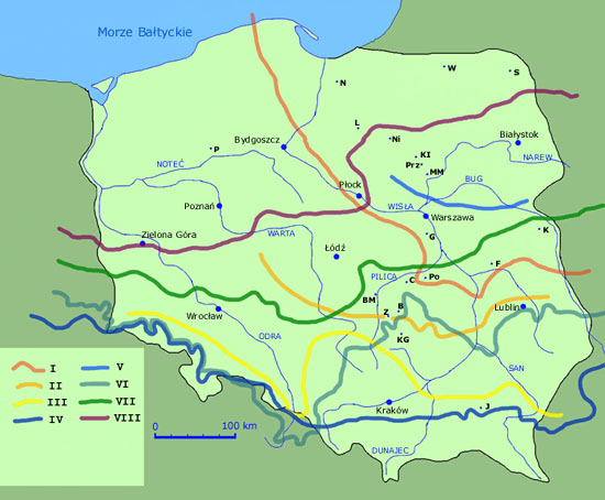
Lower Silesia (in Polish: Dolny Śląsk; in Czech: Dolní Slezsko, in Latin: Silesia Inferior; in German: Niederschlesien) is the northwestern part of the historical and geographical region of Silesia in the south-west Poland.
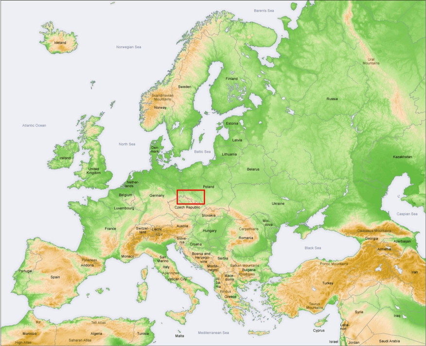
The landscape of the Lower Silesia changes from lowland to mountains as from the north to the south. Main two large geographical regions are therefore distinguished: the Silesian Lowlands and the Sudety (Sudetes) Mountains.
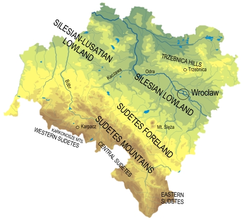
The Silesian and Silesian-Lusatian Lowlands are separated by the valley of river Kaczawa, and from the Sudetes by a steep morphological edge located along the Sudetes Marginal Fault, extended from Bolesławiec (the northwest) to Złoty Stok (the southeast). The southern part of the Lowland includes the Sudetes Foreland, consisting of quite low Wzgórza Strzegomskie (Strzegom Hills, 232 m), group of Ślęża (Mount Ślęża, 718 m), and Wzgórza Niemczańsko-Strzelińskie (Niemcza-Strzelin Hills, 392 m).
In
a geological sense, the Sudetes Foreland is a part of the Sudetes
Mountains and was created as a result of tectonic movements which
separated one crystalline massif into two parts: a mountain uplifted
part and a tectonic foreland (lower) part. The foreland remained a not
very high plain with a few elevations, thus its morphology is similar
rather to the Silesian Lowland than to the Sudetes. The eastern part of Silesian Lowlands consists of the wide plains, located along banks of the Oder River. From
the north, the lowlands are delimited by the Wał Trzebnicki, consisting of
chain of hills that are 200 km long and over 150 m high.
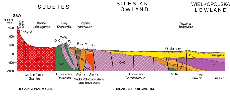
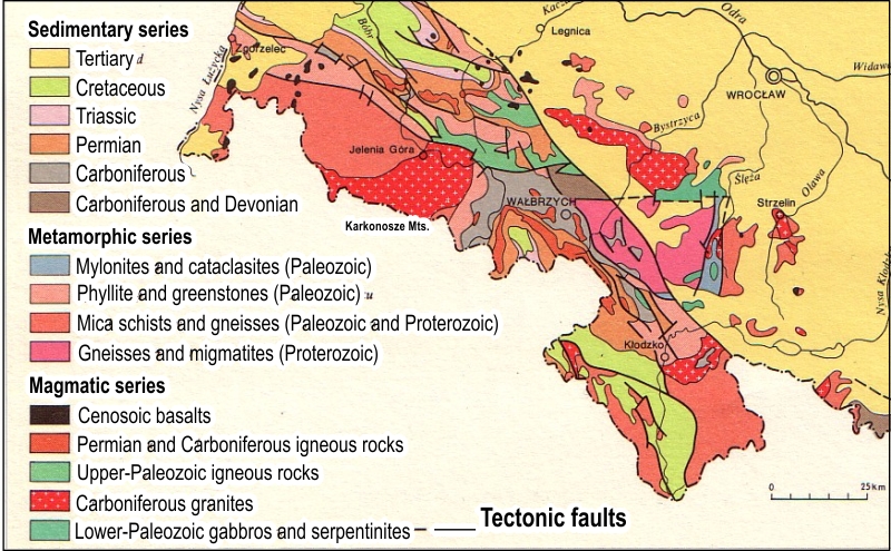
The Silesian Lowlands are situated on two major geological units. The older one is a Fore-Sudetic Block, stretching north from the Sudetes, between the Large Marginal Fault and faults of the middle Odra. Fore-Sudetic block is built of the a series of Proterozoic-Paleozoic crystalline rocks, revealing on the surface only in few locations as the Mt. Ślęża massif, Strzelin Hills, and Strzegom Hills. The fault zone of the middle Odra separates the Fore-Sudetic Block from the Fore-Sudetic Monocline filled with the Permian-Mesozoic sedimentary rock series. Both geologic units are covered with the complex of Cenozoic (Tertiary and Quaternary) sediments. Crystalline substrate of the Fore-Sudetic Block is formed by the Proterozoic metamorphic schists, gneisses and granitoids, and, in the southern part, amphibolites and serpentinites. The vast majority of these rocks was formed by metamorphic transformation of the Paleozoic and older sedimentary rocks. Proterozoic rocks lie directly beneath the Carboniferous or Permian sandstones, and in many sites are discontinuous due to intrusions of igneous rocks. Some of them are revealed on the surface, as the Variscan granitoides in Strzegom and Strzelin, and basalts near Strzegom. The serpentinite-gabbro massif of Mt. Ślęża is not a typical intrusion, but a kind of ophiolite, i.e. crystalline fragment of earth’s crust at former oceanic bottom. The Fore-Sudetic Monocline is filled with the Permian, Triassic and Cretaceous sediments, each of which are developed in the series of layers with a thickness of 100-400 m. With the exception of hills made up of crystalline rocks, all older rocks are covered with a thick (100-400 m) continuous Tertiary/Neogene series that include unconsolidated Miocene clays, sands and gravels, with thin lenses of lignite in the upper part. Tertiary sediments often occur almost on the surface, e.g. in the western part of Wroclaw are revealed in the pits of the former brickworks.
Quaternary sediments of the Silesian Lowlands are mainly developed as two-three generations of moraine deposits formed during San and Odra glaciations, and during Warta glaciation in the northern part of the region. There are complexes of tills separated by discontinuous layers of glacio-fluvial sands and gravels, and locally also with the lacustrine silts, sands and clays. Large areas of the Silesian Lowland and the Sudetes Foreland are covered with a thin layer of loess-like sediments, usually thinner than 100 cm and completely decalcified. In most locations it is a “secondary loess” that means loess redeposited from original location or transformed by cryogenic processes, mass movements on slopes or wind/water erosion. Only in certain areas, where the thickness of loess reaches 3 or even 6 meters, preserved are primary structures of eolian sedimentation and carbonates are still present in loess profile. Loess covers on the Silesian Lowlands, however, have too small thickness for a development of the typical “loessian” surface morphology, which can be observed on thick loess covers in south-eastern Poland.
Pleistocene glaciations on the Polish territory. South limits of the glaciation: I – NAREW (Günz), II – NIDA (Mindel 1), III – IV SAN 1-2 (Mindel 2-3, Elster),
V – LIWIEC (Elster), VI – ODRA (Riss 1, Saale – Drenthe, early Illinoian, Dnepr), VII – WARTA (Riss 2, Saale – Warthe, late Illinoian, Moscow),
VIII – WISŁA/VISTULIAN (Würm, Weichsel, Wisconsin)
Large parts of plains and hill-slopes in the Lower Silesia are coated with fertile loams or silt loams and therefore they became the lands for people to settle and cultivate intensively. Not only fertile grounds, but also mild climate is conductive to development of agriculture. The mean annual air temperature of the Wrocław area is 9.5 °C. Mean air temperature of the hottest month (July) is 19 °C, and −0.5 °C of the coldest month (January). The mean annual precipitation is 500–620 millimeters, with its maximum in July and minimum in February. The snow layer disappears after 45 days. Finally, the growing period reaches 230 days and belongs to the longest on Polish territory. The dominant winds are west and southwest.
The Sudetes are
geologically diverse mountains that stretch for 280 kilometers
from the Lusatian Gate on the east to Moravian Gate on the
west. The Sudetes topographically are divided into West and East
Sudetes. In the region of the Sudetes, the Izerskie Mountains (Wysoka
Kopa, 1,126 meters) are spread along with the Karkonosze
(German: Riesengebirge, also known as in English: Giant's Mountains,
with Śnieżka (Schneekoppe), 1,602 m), Rudawy Janowickie
(Skalnik, 945 m), and the Kaczawskie Mountains (Skopiec, 724
m). In terms of
geology and morphology, the Sudetes consist of several distinct
massifs, built of different rocks and uplifted during different orogens.
The history of
the Sudetes begins in late Precambrian era with formation of gneisses
of Sowie Mountains Middle Sudetes). Even during late Precambrian era
were formed gneisses and crystalline schists in the Izerskie Mountains
and Karkonosze (West Sudetes), as well as greenstone shales of the
Kaczawskie Mountains. At the end of the Precambrian and early Paleozoic
era, present Sudetes were seabed manifesting volcanic activity. It was,
however, area of significant sedimentation of clastic materials that
later built sedimentary rocks - sandstones, claystones and marls. During the
Caledonian orogeny sea withdrew, and huge Pre-Sudetes mountains were
uplifted. Older sedimentary and igneous rocks of the previous era were
in many sites transformed into metamorphic rocks (Precambrian granite
were turned into gneiss, sedimentary rocks - into crystalline schists,
etc.). Then, by about 100 million years, took the destruction of the
Caledonian mountains. Between the hard gneiss blocks of Early Sudetes
arises the great depression, which gather sedimentary materials from
surrounding highlands. These rocks will later form the central mountain
ranges of Sudetes. Old Caledonian
massif was divided during Hercynian/Variscan orogeny (Paleozoic era)
and only the eastern part of Sudetes was uplifted. At the same time, an
acid magma injected between the sedimentary rocks and created a large
intrusion of granite – the crystalline block of the
Karkonosze-Izerskie Mountains. Also other igneous rocks –
porphyries and melaphires – ware formed in central Sudetes in the
Paleozoic era (Carboniferous - Permian) as a result of high volcanic
activity. Moreover, in the Intra-Sudetic Trough (basin) a sedimentation
of clastic materials continued almost incessantly. Repeated shallowing
(upper Carboniferous) transformed the basin into a huge swamps. Thick
peat layers later became a coal. At the end of the Paleozoic era, a
large transgression of sea covered entire Sudetes - apart from the
highest parts, among others Karkonosze and Izerskie Mountains. However,
denudation gradually destroyed their Caledonian metamorphic and
sedimentary rocks. The Kimerian orogeny led first to the sea regression
and the erosion of uplifted sedimentary rocks of the Paleozoic period,
and then (during the upper Cretaceous period) to secondary
transgression of sea. As earlier, the highest parts of Sudetes –
“Variscides” - the Karkonosze, Izerskie and Sowie Mountains
remained over the water and provided clastic materials that settled in
a warm Cretaceous sea. Thick layers of sands and clays, became later
sandstones and marls and build the present Stołowe Mountain that have
unique platy, non-folded structure.
The last Alpine
orogeny (Neogene period) finally uplifted the Sudetes Mountains over
the Silesian Lowlands and diversified the internal structure of
mountain ranges. High volcanic activity have led to the formation of
dozens of basalt covers and cones, of which the highest - Bukovec (1005
m a.s.l.) – is located in the southern, Czech part of the
Izerskie Mountains. The climate during this period was warm and humid,
so the mountains were subjected to a great chemical weathering and
denudation, which has shaped the present system of river valleys, and
provided large volume of clays settled later in the sea north of
Sudetes (in the Fore-Sudetic Monocline).
Morphology of the Sudetes and their foreland was finally formed by the Pleistocene glaciations. First of two large glaciations – San/Mindel/Elster - covered with ice all areas up to 550 m a.s.l., while cold and dry periglacial climate favored strong physical weathering above this altitude. Scandinavian ice sheet broke up again into the mountain basins during the second of great glaciations (Odra/Riss 1/Saale-Drenthe/early Illinoian/Dnepr), bringing large quantities of clastic materials, settled as moraine or glacio-fluvial sediments. During the next glaciations - Warta (Riss 2/Saale-Wartha/late Illinoian/Moscow) and Vistulian (Würm/Weichsel/Wisconsin), the ice sheet has not reached the Sudetes, but the climate was so cold and humid, that the mountain glaciers developed above 1200 m a.s.l. The today’s remnants of former mountain glaciers are rock cirques with small lakes, the deep U-shaped valleys, and numerous lateral and marginal moraines. High activity of cryogenic slope processes in the Vistulian period led to the transformation of saprolites covering the mountain slopes, and the formation of stratified “slope cover-beds”.
The soil variability in the area of Lower Silesia is a reflection of geological, topographical and climatic diversity of the region. Based on the classification of soil regions of Europe [BGR, 1998], three soil zones were distinguished in the Lower Silesia:
- region 18.4 - Cambisols - Luvisols (south part - the Sudetes Mountains),
- region 52.2 - Luvisols - Gleysols (central, the largest part of Lower Silesia), and
- region 50.1 - Podzols - Gleysols (lowlands in the northern part of the region).
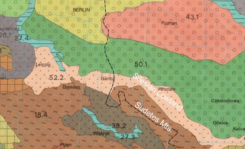
Based on "Soil region of Europe - 1:5000000 (v.1). Bundesanstalt fuer Geowissenschaften und Rohrstoffe, Berlin, 1998
The regional soil zonality is well visible on a simplified soil map (original scale 1:7500000) provided by Soil Atlas of Europe [2005].
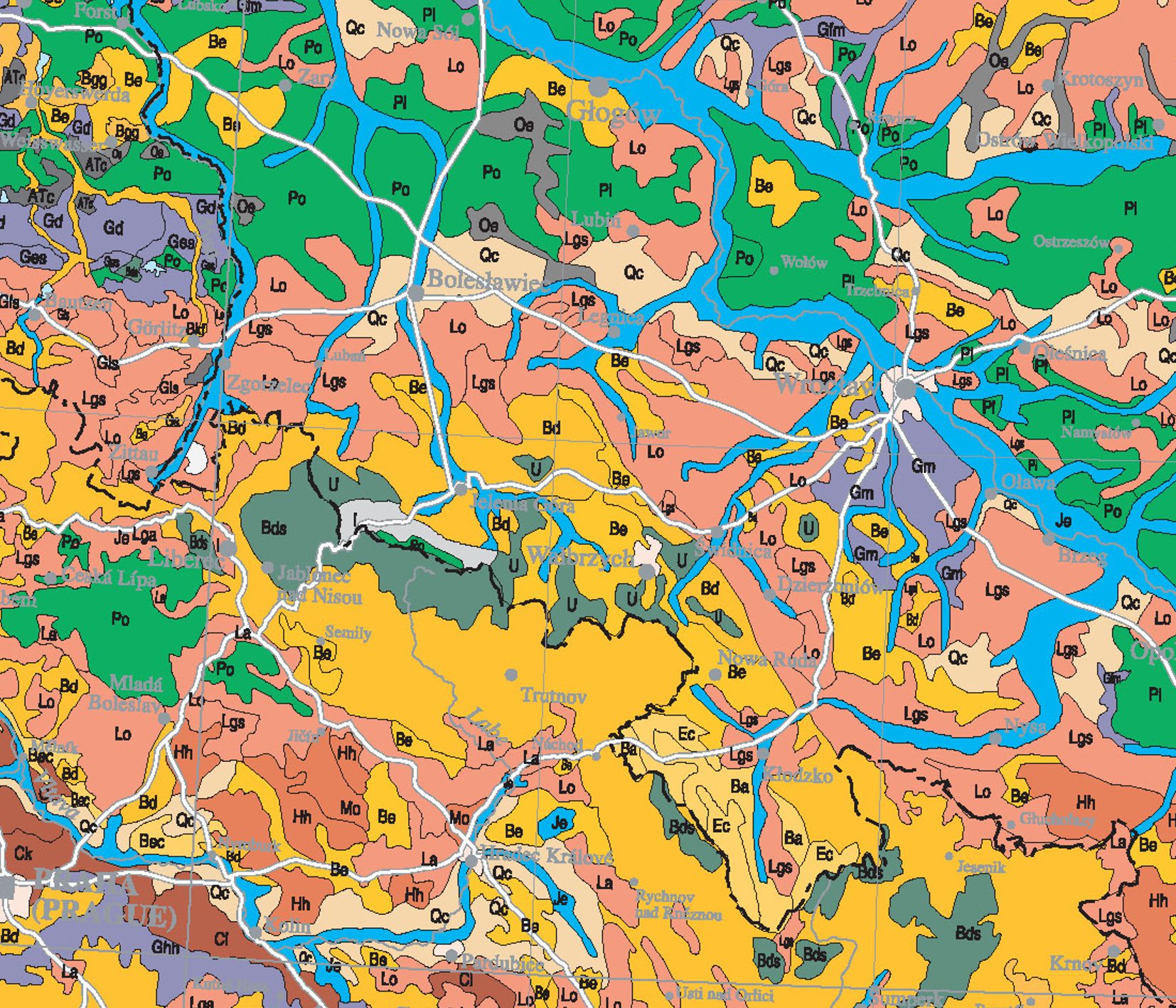
Explanation: Ba/Ec -
Calcaric Cambisols, Bd - Dystric Cambisols, Be - Eutric Cambisols, Ec -
Calcaric Cambisols,
Gm - Mollic Gleysols, I - Lithic Leptosols, Je- Eutric
Fluvisols, Lgs - Stagnic Luvisols, Lo - Haplic Luvisols,
Po - Haplic Podzols,
Pl - Episkeletic Podzols, Qc - Haplic Arenosols, U - Umbrisols
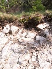
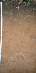
Soil cover in the Sudetes Mountains is dominated with Cambisols: primarily Dystric Cambisols, and with Eutric Cambisols in the lower slope positions and at the foot-slopes, both under forests and on arable areas. Eutric Cambisols occur on the alkaline igneous and metamorphic rocks (amphibolites, serpentinites, greenstones) and marls, as well as on various saprolites covered with eolian silts. Dystric Cambisols are developed on some igneous and metamorphic rocks (mainly granite, gneiss, mica schist), and are highly acidic and skeletal throughout the profile. They are accompanied by scattered Podzols (in particular on granites, gneisses and sandstones). The intra-mountain basins are occupied by loamy Stagnic Luvisols (and Albeluvisols or Alisols), whereas river valleys - with Fluvic Cambisols, developed of river sediments, mostly loam on sand or gravel. Most soils in this zone has the redoximorphic features (stagnic or gleyic), as well as an enhanced content of organic matter and skeletal fragments (at least in the lower part of soil profile). Quite common, but on small areas, are Dystric Histosols and Histic Gleysols. Verification is required in a case of Leptosols and Umbrisols, whose ranges appear to be overestimated [Soil Atlas of Europe 2005].
The central part of the region, that is the Sudetes Foreland and the southern part of the Silesian Lowlands, is covered with various subunits of Luvisols, Planosols, Stagnosols and Retisols developed primarily of loess, loess-like silt loams, but also from other quaternary sediments. Eutric Cambisols and eroded Luvisols prevail in the more undulating areas. The share of Dystric Cambisols is smaller, they occur mainly on the forested slopes of the hills in the south (mountainous) part of the region. Verification requires the presence of Albeluvisols, both on the loess in the wetter, sub-mountainous part of the region, as well as on stratified glacial materials in its northern part. Extensive, flat and wet lowland south of town Wroclaw is covered with "black earths", that were previously recognized as Gleyic Phaeozems, but in most cases are in fact Gleyic/Stagnic Chernozems/Phaeozems. These polygenetic soils often involve an argic, calcic, or vertic horizons below a deep mollic epipedon. Gleyic Fluvic Cambisols and Fluvic Gleysols developed of loams on river sands occur in a broad valley of the Odra river and in the valleys of its southern tributaries. Soils in this region have high and very high agricultural productivity (particularly, if developed from loess), and in the majority are under cultivation. Thus, the degree of afforestation is the smallest in the region and usually does not exceed 10%.
The northern part of the Lower Silesia (north of a line Bolesławiec - Wrocław - Odra river valley), in particular the north-western part of the Silesian-Lusatian Lowland, is dominated by soils developed from glacio-fluvial, alluvial and eolian sands. They are dry and very poor Brunic Arenosols and Podzols, in majority afforested. In the shallow depressions and wide river valleys are Fluvic Gleysols and various variants of organic and mineral-organic soils: Histosols, Histic Gleysols and Histic Fluvisols. Only in small enclaves on the end-moraine hills occur Luvisols and Cambisols developed from till or loess. The soils of the northern sub-region have (in a majority) the lowest agricultural productivity among soils of the Lower Silesia, which is reflected in a high degree of land afforestation, no less than in mountainous areas
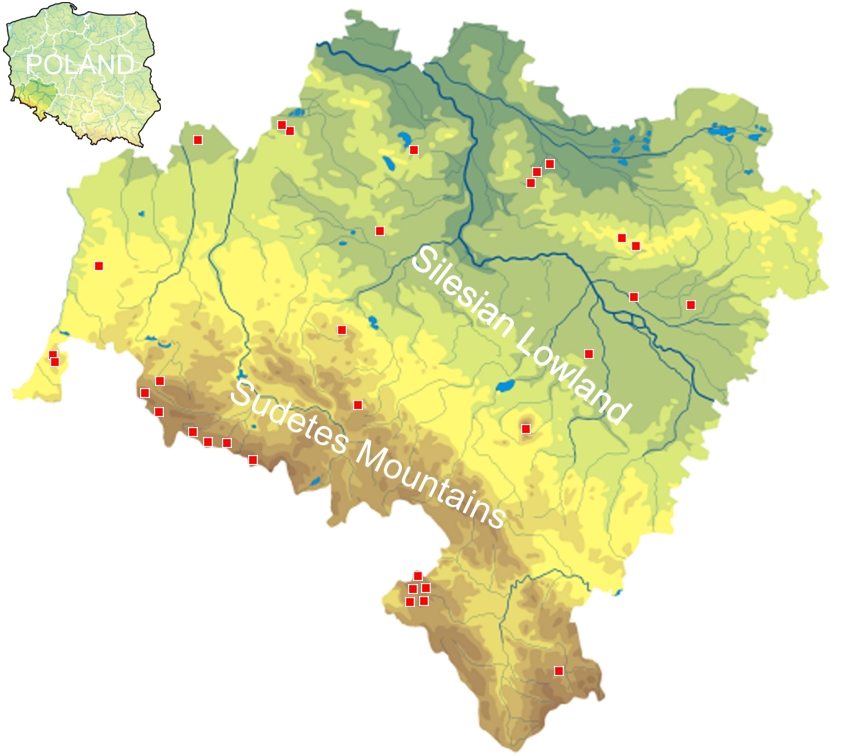
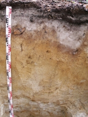
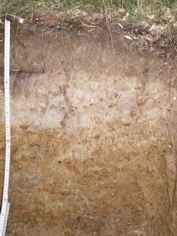
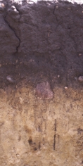
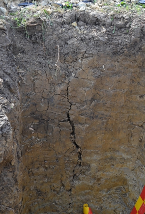
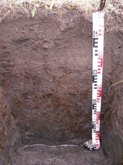
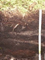
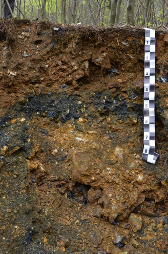
Examples of soil developed on various parent materials
and under various climate conditions in the Lower Silesia
(click to open soil type' site)